Saturday, September 5, 2015

Crocker Sugarloaf Spaulding

If You're A Moose I'd Recommend Staying The Hell Away From Spaulding Mtn.

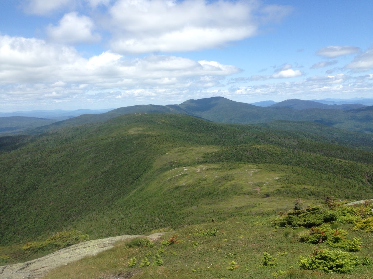
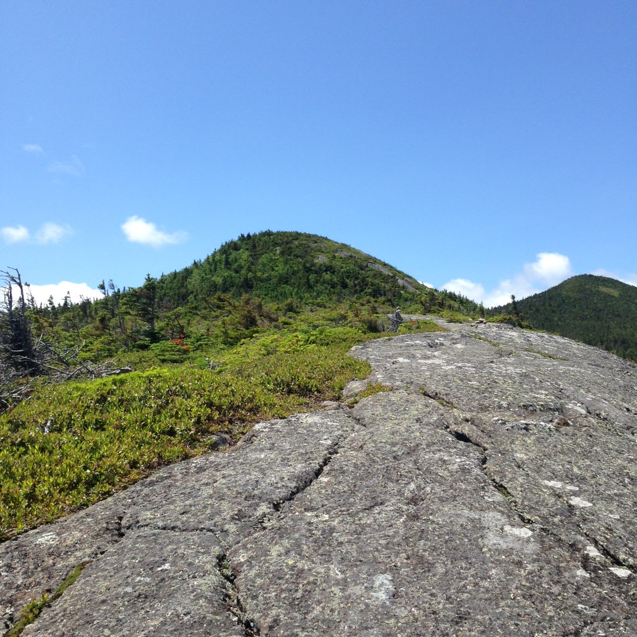
Some of the most challenging terrain that the AT offers. Excellent views from the top of Sugarloaf. The ascent from the South Branch Carrabassett River up Sugarloaf is hands on vertical at points. Some runnable terrain mixed with a whole lot of boulders and rocky footing. Welcome to Maine. You can also choose to hike Crocker Mountain and loop back to the trailhead on 27 via the Caribou Valley Road. It's called the Crocker Cirque. 


Friday, September 4, 2015

Bigeloop

From The Summit Of West Peak Looking North Bound At Avery And Little Bigelow In The Back

Easily my one of my favorite places to run in the world. The Bigelow Range is stunning. This was my first time doing the classic loop ascending the Fire Warden's Trail, traversing the AT south bound, then descending the Horn's Pond Trail. 

Dear Everyone, Do this loop! Love, Colin

Sunday, August 30, 2015

Mount Cabot


Great day trotting around New Hampshires most northern 4,000 ft peak with my buddy Squirrel. Part of the Pilot Range. Named after a dog called Pilot who use to live in these woods. So they say.

Friday, August 28, 2015

Grafton Loop Trail FKT (Attempt)

STRAVA DATA

On Friday August 28th I attempted to set a new FKT (Fastest Known Time) for the Grafton Loop Trail. After weeks of humidity, the cold front finally passed, and the day was dry and much cooler (high 70's) then the two training runs I had done out there the week before. My goal was to run under the 9:29:30 time set by Adam Wilcox and Ryan Welts last summer. I didn't taper or treat it like an A race, but though of it more like a training run for Grindstone 100, my first attempt at 100 miles, which I will be running in October. I did feel good and thought the record was attainable that day. As mentioned by Adam and Ryan in regards to their effort, they were not pushing hard and set a softer FKT that would probably/hopefully be broken and reset a few times. Something that makes these thing more fun to go after.

I drove up early that morning from Portland and headed to the northern Grafton Notch State Park parking area where I cached some water and food. I then drove back to the southern parking area at the base of Puzzle Mountain where I began my run. I went counter clockwise, the same as Adam and Ryan. After some recon I think it's the faster direction, though if I were to do it again, I might start at the northern trailhead and begin with the Old Speck climb. I think the East side is easier even though it's longer and would prefer to do it last. A few seconds after 7:20am I started my watch and began to run.

I felt great on the climb up Puzzle Mountain. The morning air was cool. I was running with my heart rate monitor and wanted to keep my HR lower than 145 for the day. It's a comfortable aerobic pace for me uphill, and I figured I could hammer the downhills and stay well below that. I don't really pay attention to splits and barely looked at my watch all day. When trail running, I try and run by feel and HR. I try and just be present moving through the woods and not think about time or pace. I like checking my pace if I'm racing roads, but generally just run by feel almost all the time no matter what the surface.

The descent down Puzzle is very runnable and I was feeling great. Except my heart rate monitor kept slipping and I had to take it off which frazzled me a little bit as I was planning on using it as my main metric for the day. (I hate chest straps and look forward to the day that all HR monitors use wrist technology.) I wanted to chuck the damn thing in the woods, but though a poor bear would feel sad about not having the watch to use it with, so I tucked it away in my pocket.

Overall the east side of the trail went excellent. I was feeling good and like I had the energy to go all day. I was moving well and pretty sure that I was keeping up with Adam and Ryan's pace at this point. There is a beautiful large creek that follows the trail for a while around mile 10-11. I don't know what it's name is, but it's the same one that comes out at Step Falls on Rt 26. I was running with a 2L hydration bladder with Tailwind and water in it, had plenty, but had planned on using my Sawyer Mini Filter and squeeze bag here to stay topped off on water and not have to drink so much at the northern trailhead. Because the weather was so cool, and I wasn't sweating a lot, I decided to pass and keep my momentum and speed going. In retrospect, I should have stopped, and I paid for it later.

From here the trail goes up along lightning ledge, drops back down, then heads up to the Baldpates, the AT, then drops down rather quickly back to Rt 26. Its about 10 miles from the river I mentioned to the road. This section, though still easy to follow, is littered with blow downs, which makes it harder to keep a consistent pace. The trail is over grown a lot, so even though the footing is ok, you can't see it, and need to hike and go pretty slow. Once you hit the AT it's fine. You then just have to deal with the rocks and roots associated with a heavily trafficked trail.

I reached the road around 5 hours and 15 minutes. This was the first time I looked at my time and I was pretty sure it was about the same as Adam and Ryan's pace. I knew then that I would have to continue to feel strong to out run their west side time. I stopped to change out my hydration bladder, drink some water, and also some coke. This was partially a training move, as I wanted to experiment with Coke as a caffeine/fuel for Grindstone. Not sure if it was the coke, dehydration, or inadequate Tailwind fuel levels to this point, but this is where things started to fall apart for me. Adam mentioned struggling up Old Speck with water sloshing around in his stomach from drinking too much when they crossed the road. I had planned on avoiding this by drinking at mile 10, but since I didn't, I ended up consuming too much before going up Old Speck.

Old Speck is a rugged climb, but I've never thought of it as being extreme. On this day it was a killer. I was moving real slow, feeling nauseous, and weak. I wanted to eat something (even though I didn't feel like it) but wanted to wait until the top when I reasoned that it would be easier to digest on the descent. I finally got up to the turn to the summit and off the AT after almost an hour and a half climb. I ate a packet of Justin's Peanut Butter and had a hard time getting it down. I used lots of Tailwind water in my mouth to wash it down because I couldn't swallow it. I also realized somewhere on the climb that the hydration bladder I was now using was a new one I had had for a long time but never used. It had that terrible chemical plastic taste, and made drinking out of it really unappealing. This didn't help me keep up my hydration on the second leg, and was another factor in my weaker performance on the west side.

The trail down Old Speck is very runnable and I was happy to be moving faster than 30min/mile. But the day was getting hotter, I was getting dryer, and my stomach was starting to hurt. Somewhere between here and Sunday River White Cap, the stomach cramping got real bad and I had a hard time running even the flats and downhills. Exactly the same thing that happened to me at the Vermont 100K this year. This is when knew the record was not going to happen for me that day. As mentioned by Adam and Ryan in their interview on DFL ultra running, this side of the loop is deceptive. I had even run it the other way a week before, and was totally surprised by some of the climbs. You think there is just a couple, but they keep coming and coming like they're never going to end! I was somewhere near Bald Mountain when I checked my watch and saw that I was already at 9 hours and 30 minutes. At this point I slowed even more. After making it down the steeper sections, and only a mile or two from the road, I stopped to filter water and drink. I wanted to let my stomach relax and also see how water would help the pain. I didn't care if it delayed my finish time by a few minutes. The stop did help some and made it easier to continue on. I took an especially easy running pace down the snow mobile trails and road back to the parking area and stopped my watch at 10:22:28. Which, for what's it's worth is now the unsupported FKT for the Grafton Loop Trail.

I had a great day, then a not so great day out there. I learned a lot about my fuel and hydration needs. I realized when I got back to my truck that I had only drank maybe 20 of the 80 oz of water in my bladder. The combination of Tailwind with the foul plastic taste really hampered my hydration, and not fueling enough effected my mental state. I had no idea how little I was drinking. It could have been more dire if the weather conditions were what they were a week before. I did get a great training run in, and feel awesome about completing this entire loop. The climbs are relentless and the trail makes you focus the entire time. I did take away some important lessons that I hope help me at Grindstone in a month. I highly recommend that people get out and run/hike/enjoy this loop. It doesn't get a lot of traffic and feels very remote in certain spots. It's a special part of Maine. I feel lucky to have experienced it in such a unique way.

Friday, August 21, 2015

Grafton Loop Trail


MAINE TRAIL FINDER MAP

STRAVA DATA - WEST SIDE
STRAVA DATA - EAST SIDE 

DFL Ultrarunning Podcast Interview w/ Adam Wilcox and Ryan Welts about their FKT run of this route in 2014

Description from Maine Trail Finder:

The Grafton Loop Trail is a 38.6 mile, backcountry hiking experience in the Mahoosuc Mountains of Maine. The trail, which connects to the Appalachian Trail at Old Speck and the East Peak of Baldpate Mountain on either side of ME Route 26, highlights the natural features and mountain peaks of the area encircling Bear River Valley. Because of its length and the terrain it traverses, the trail is strenuous and requires appropriate equipment and preparation.

This week I ran the Grafton Loop Trail. I first ran the 17.5 mile west side and two days later ran the 21.1 mile east side. (My GPS said more like 16 and 19 miles.) It was hot with zero wind when I did the east side, and very humid but slightly cooler with cloud cover when I did the west. I ran both routes starting at the southern parking area across from Eddy Rd. I left my truck at the northern Grafton Notch State Park parking area and biked the 7.5 miles back. Almost all downhill which was nice but the logging trucks and lack of shoulder were a bit sketchy. As for hiking, I felt like I was going uphill the entire time on the west side, where the east felt more runnable. It's all pretty technical. The footing was always tricky even in the more runnable sections. Both had sections that were slightly over grown, but the east side was much less cared for with many blowdowns, especially between Long Mountain the Baldpates. Plenty of water sources along the entire trail even in a dry late August. I didn't take many pictures as the sweat on my phone wouldn't allow me to open it up a lot of the time. Here are a couple. This entire trail is beautiful and doesn't see a lot of traffic. If planning a full loop I would recommend traveling counter clockwise. 


From Sunday River White Cap looking north up the notch with view of highway 26. Old Speck on the left. Baldpates off to the right.

Fire tower on top of Old Speck.


I only used water and tailwind both days but carried a lot of extra emergency gear.  I always like to be prepared for at least 24 hours out there if something goes wrong. Especially traveling alone with spotty cell coverage. 

Puzzle Mt. in the clouds.

From East Baldpate


Sunday, August 2, 2015

Pemi Loop

Finally ran this iconic 30 mile route. Beautiful day. Rather crowded, especially along the Franconia Ridge, but what you'd expect on a midsummer Sunday. Here is a link to more information about the loop as well as my route and data on STRAVA


Thursday, July 2, 2015

Mahoosuc Range - Goose Eye + Mount Carlo Via Wright Trail

 Wright Trail - Maine Trail Finder


Looking North Towards Old Speck and Grafton Notch

Valley Cliffs From Wright Trail


Looking East Towards Sunday River Ski Resort


Exposed Ridge Line Leading Towards Goose Eye

Goose Eye From Neighboring Peak


Goose Eye From The Descent Of Mount Carlo


Steep Climb Up Back Up Goose Eye From Carlo


Saturday, June 20, 2015

Mt Washington Road Race - Race Report

The Mount Washington Road Race is a 7.8 mile paved hill that includes 4,650' of elevation gain between 12% and 22% grade. As the race organizers like to say, "Relax. There's only one hill." This was the 55th year of the race. There were over 1000 people including a 95 year old man who finished in last place.

My body was feeling good leading up to the race. The race took place during the peak of my Vermont 100K training so I was a little less rested, but I was able to do a mini taper that week to try and get my legs ready. And they were. My legs felt great. The issue I did have was my stomach. I made some fueling mistakes, took some gels (which I don't normally do), and just had too much in my stomach for such a short race. I have never had GI issues running but from mile 3-5.5 I felt on the verge of puking. In retrospect I should have. I think it would have made me feel better and get running again sooner. Instead I walked it off, eventually felt better, and had a great finish for the last mile and a 1/2. That being said, this is a tough ass race that I underestimated to a degree. I did a lot of hiking and climbing this winter and spring, including multiple trips up Washington with skis on my back, and felt like I was more prepared than I was. The roads are cambered a lot so not only do you feel like you are going up all the time, but if you fall off to the side of the road it feels like you are going down hill and have to climb up even further. Even when you know it's all up hill, its hard to not hope that there will be a flat section around the corner! I had a goal of finishing in 1 hour 20 minutes and ended up finishing in 1:30:30. My split at the 1/2 way mark was 41 minutes which was right on track. But things started to fall apart right around then. I actually was surprised that I finished in 1:30 considering how I was feeling and that I walked almost two miles. It was one of those races that made me question why I run/race at all and at the same time made me eager to get in the lottery for next year and do it again! Thank you to Maine Track Club, Trail Monster Running, all the volunteers, and the Hoff girls for crewing and all the support.

Tuesday, May 26, 2015

Monday, May 18, 2015

Monday, April 27, 2015

Woodhaven - Burnsville - The Black Mountains Of North Carolina


Pisgah National Forest 

State Moto: To Be, Rather Than To Seem


There Be Dragons


Pisgah

Black Mountain Crest Trail 

Pisgah National Forest From Mt Craig

EB

Wood Haven


Top Of The East

Friday, April 17, 2015

2015 Tuckerman Inferno - Race Report


MORNING LIGHT ON MT. WASHINGTON


A few pictures and a brief race report from the Tuckerman Inferno Pentathlon. The inferno is an 8 mile road run, 6 mile flat and class I whitewater kayak, 18 mile bike to Pinkham Notch, 3 mile hike up Tuckerman Ravine, followed by about a 2 mile ski downhill. My watch said the total elevation gain was 5,728' and 34.3 miles. It was a very windy day. Challenging course. I didn't train much. Ran roughly 5 days with one over 5 miles since November. Got in a kayak the day before the race. Before that it had been a few years. Don't think I have ever ridden a bike that far. Felt good about the hike and ski. I've been skiing all winter. Also uphill skinning about once a week. The run felt great. Wind effected the kayak. Water level in the Saco River was low. Dry areas and hard to navigate boulder fields. The sun was out for a little while and directly in our eyes. Still plenty of ice on the river. My foot rests were not adjusted properly. I think it contributed to the leg cramping I experienced the rest of the race. A few times during the bike ride I had to stop because of cramps. Fortunately it felt better going uphill. And that's pretty much all we did. 2k vertical feet on the bike ride up to Pinkham notch. 18+ miles. Started to snow. Wind was strong. Gusts up to 40 maybe. At one point I got pushed into the highway. Close call with a car from Massachusetts. Also felt nauseous most of the bike and hike. Used Tailwind for fuel. Usually doesn't make me feel bad. I think part of my cramping and nauseous came from generally eating a shitty diet lately. I felt ok on the hike up to Tuckerman. Managed to keep a steady pace and not stop. The wind did as well. Top gust for the day at the summit was 127mph. I felt most trained for the ski down. But by the time I got to the top my legs cramped up so much that I couldn't get my boots on. Needed help from two people. My quads were shot during the downhill. The conditions were awesome, but harder to enjoy, with my leg muscles alternating between cramping and burning. Used some pretty ugly technique to get down. Was still fun! 12th place in the Tuckerman division. 4:33:21. Can't thank Cecily enough for crewing and taking some pictures. Such a huge part of a race like this. Would have bailed on doing the race at all if it wasn't for her. Thanks to Friends of Tuckerman Ravine for putting on the inferno and for being great stewards of a very special part of the world. You can support them HERE.

STRAVA INFO